
Gallery of new files
This special page shows the last uploaded files.
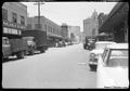 June 1959 Produce District, now the Golden Gateway, view south on Drumm across Washington toward Market. Jacobs Malcom & Burtt on left wnp14.10237.jpg Ccarlsson
14:40, 17 January 2020
1,000 × 699; 206 KB
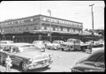 May 1959 Davis and Washington View of old Produce District, demolished for Golden Gateway Center; John Di Martini Co., Farmers Exchange wnp14.11135.jpg Ccarlsson
14:38, 17 January 2020
1,000 × 697; 226 KB
 1959 Golden Gateway site, Sydney G. Walton Square; Columbo Market Arch, Front between Jackson and Pacific, Produce District wnp28.2474.jpg Ccarlsson
14:35, 17 January 2020
1,000 × 658; 213 KB


 International Hotel at 848 Kearny Street in San Francisco, around 1979 Nancy Wong Wikimedia Commons.jpg Ccarlsson
21:11, 14 January 2020
1,280 × 873; 302 KB
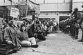
 Housing activists protest outside San Francisco City Hall, 1977 Nancy Wong.jpg Ccarlsson
21:10, 14 January 2020
1,536 × 1,024; 771 KB
 Protesters form in front of the I-Hotel, January 1977 Nancy Wong.jpg Ccarlsson
21:08, 14 January 2020
1,536 × 1,024; 869 KB


 George Woolf of Tenants and Owners in Opposition to Redevelopment (TOOR) 1970 TOR-0092.jpg Ccarlsson
20:34, 14 January 2020
253 × 400; 41 KB

 Cc-and-halloul-at-fernando-eviction-protest 20190531 113713.jpg Ccarlsson
19:28, 14 January 2020
792 × 594; 191 KB


 1918 Elsie-Esmeralda looking southwest dpwbookXXX dpw5221 College Hill Reservoir in background wnp36.04147.jpg Ccarlsson
00:07, 13 January 2020
1,000 × 689; 316 KB
 1918 Elsie-Eugenia looking northeast (postman & kids) dpwbookXXX dpw5227 wnp36.04148.jpg Ccarlsson
00:05, 13 January 2020
1,000 × 696; 345 KB
 July 28 1921 Intersection of Coso, Lundys Lane, and Montezuma Street before paving dpwbook30 dpw7220 wnp36.02610.jpg Ccarlsson
23:54, 12 January 2020
1,000 × 709; 409 KB
 March 30 1928 view southeast down Coso Coso Ave from Prospect dpwbook41 dpwA971 wnp36.03625.jpg Ccarlsson
23:52, 12 January 2020
1,000 × 698; 382 KB
 March 5 1929 Coso (steep hill) from Prospect dpwbookSPECIMP16 dpwA1680 wnp36.04241.jpg Ccarlsson
23:50, 12 January 2020
1,000 × 693; 309 KB
 March 4 1919 View east at the intersection of Coso and Prospect dpwbook24 dpw5854 wnp36.02078.jpg Ccarlsson
23:49, 12 January 2020
1,000 × 730; 439 KB
 April 14 1926 DPW 10283 Coso Ave - Missing DPW Album. Duplicate of wnp36.03451 wnp27.0510.jpg Ccarlsson
23:47, 12 January 2020
1,000 × 682; 256 KB
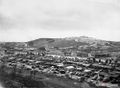 Aug 10 1948 Farmer's Market looking southeast St. Joseph Hill in background wnp27.5586.jpg Ccarlsson
23:43, 12 January 2020
1,000 × 734; 248 KB


_1970_TOR-0092.jpg)
_on_panel_at_a_meeting_of_Tenants_and_Owners_in_Opposition_to_Redevelopment_(TOOR)_at_Milner_Hotel,_117_4th_Street_Dec_1970_TOR-0135.jpg)


_dpwbookXXX_dpw5227_wnp36.04148.jpg)
_Elsie_near_Virginia_looking_northeast_dpwbookXXX_dpw5222_wnp36.04146.jpg)


_from_Prospect_dpwbookSPECIMP16_dpwA1680_wnp36.04241.jpg)


._Bernal_Heights_and_site_of_US101_freeway_in_background._Oakdale_Ave_to_Bernal_dpwbook36_dpw10221_wnp36.03371.jpg)