
Gallery of new files
This special page shows the last uploaded files.
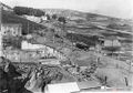
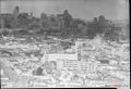
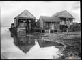
 March 14 1915 Islais Creek E from Hill dpwbook11 dpw2272 looking north to Potrero Hill wnp36.00729.jpg Ccarlsson
23:22, 12 January 2020
1,000 × 619; 336 KB
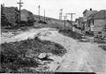
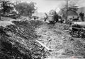
 March 4 1915 Islais Creek San Bruno nr Cortland (sunken street) dpwbook11 dpw2275 wnp36.00732.jpg Ccarlsson
23:19, 12 January 2020
1,000 × 702; 361 KB
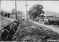
 March 4 1915 Islais Creek, San Bruno Avenue near Cortland (sunken street) dpwbook11 dpw2274 wnp36.00731.jpg Ccarlsson
23:17, 12 January 2020
1,000 × 699; 374 KB
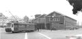 1940 Market St. Railway streetcar 403 at Valencia Car House at Duncan. 0403-35-A VALENCIA YARD 1940 wnp5.50676.jpg Ccarlsson
23:11, 12 January 2020
1,000 × 486; 110 KB

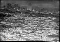
 C1936 View North from Bernal Heights. Harrison Street at center. Precita Park, SF General Hospital, Bay Bridge under construction wnp27.6089.jpg Ccarlsson
22:50, 12 January 2020
1,000 × 628; 338 KB
 July 1923 View east over Bernal heights, Maxwell Cars parked on hill with Ad wnp15.1437.jpg Ccarlsson
22:44, 12 January 2020
1,000 × 719; 473 KB
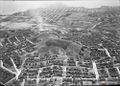 July 1923 Bernal aerial Maxwell cars parked on top of hill as part of ad campaign wnp15.393.jpg Ccarlsson
22:41, 12 January 2020
1,000 × 714; 392 KB
 Nov 14 1952 Seals Stadium and Hamms wnp14.10636.jpg Ccarlsson
22:35, 12 January 2020
1,000 × 654; 346 KB
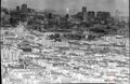
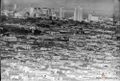 Nov 14 1952 View from Bernal Heights to downtown wnp14.10635.jpg Ccarlsson
22:30, 12 January 2020
1,000 × 672; 357 KB
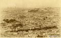
 1938 Looking north from Bernal Heights, with bird flying over skyline wnp27.3301.jpg Ccarlsson
22:28, 12 January 2020
1,000 × 697; 276 KB

 Aerial 1935 Bay Bridge construction visible wnp37.10060.jpg Ccarlsson
22:14, 12 January 2020
1,000 × 690; 309 KB
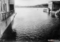
 Under bay bridge 1961 w Hills Bros and Pac Tel bldg wnp25.5823.jpg Ccarlsson
22:11, 12 January 2020
1,000 × 637; 213 KB
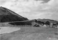
 Nov 24 1941 View Southeast toward Alemany Boulevard and Silver Terrace from the east edge of St. Mary's Park (St. Mary's Recreation Center) DPW A7043 wnp26.051.jpg Ccarlsson
17:49, 10 January 2020
788 × 1,000; 358 KB
 India Basin View north towards Hunters Point Power Plant, Bay Bridge c 1949 wnp25.4553.jpg Ccarlsson
15:46, 9 January 2020
1,000 × 955; 380 KB
 View of Hunters Point Shipyard and Gantry Crane c 1949 wnp25.4554.jpg Ccarlsson
15:42, 9 January 2020
1,000 × 793; 325 KB
 Two classical revival buildings beside two dry docks. Nov 1919 wnp37.04273.jpg Ccarlsson
15:41, 9 January 2020
1,000 × 700; 264 KB
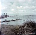
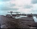
 Hunters Point slip c 1900 G810 SH-593 GGNRA-Behrman GOGA 35346 wnp71.0346.jpg Ccarlsson
15:40, 9 January 2020
1,000 × 809; 227 KB
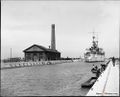 Hunters Point slip c 1900 Battleship entering slip. Pumphouse with tall smokestack at end of pier. G810 SH-592 GGNRA-Behrman GOGA 35346 wnp71.0345.jpg Ccarlsson
15:38, 9 January 2020
1,000 × 812; 224 KB
 Aerial view Hunters Point circa 1910 wnp33.03943.jpg Ccarlsson
15:33, 9 January 2020
1,000 × 695; 270 KB
 View West on Oakdale toward Phelps. Haley and ONeill Homestead, South San Francisco M.E. Church on left c 1865 wnp26.685.jpg Ccarlsson
15:19, 9 January 2020
1,000 × 766; 319 KB

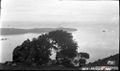
 View North from Bayview Hill across Bayview District to Hunters Point, Yosemite slough 1953 wnp28.1106.jpg Ccarlsson
14:56, 9 January 2020
1,000 × 712; 333 KB
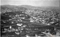
 Oakdale near Griffith Jan 4, 1916 wnp36.01140.jpg Ccarlsson
14:33, 9 January 2020
1,000 × 727; 264 KB
 Innes bet Griffith and Fitch dpwbook19 dpw4440 June 13 1917 wnp36.01619.jpg Ccarlsson
14:30, 9 January 2020
1,000 × 709; 388 KB
 Islais Creek flood Jan 25 1916 Islais Creek SW from trestle dpwbook15 dpw2992 wnp36.01166.jpg Ccarlsson
14:22, 9 January 2020
1,000 × 615; 252 KB
 Islais Creek flood Jan 14 1916 North from RR Ave & Hudson dpwbook15 dpw2981 wnp36.01160.jpg Ccarlsson
14:16, 9 January 2020
1,000 × 707; 280 KB
 Islais Creek flood Jan 14 1916 North from Phelps n Jerrold dpwbook15 dpw2980 wnp36.01159.jpg Ccarlsson
14:13, 9 January 2020
1,000 × 715; 262 KB
 Hunters Point School 901 Innes dpwbook21 dpw4861 Sept 19 1917 wnp36.01760.jpg Ccarlsson
14:09, 9 January 2020
1,000 × 807; 366 KB
 Northerly-view-on-Pennsylvania-St 20190901 174528.jpg Ccarlsson
15:01, 7 January 2020
792 × 432; 102 KB


_dpwbook11_dpw2275_wnp36.00732.jpg)
_dpwbook11_dpw2274_wnp36.00731.jpg)


_looking_north_toward_Glen_Park;_Fairmount_Heights_to_the_left,_Holly_Park_and_Bernal_Heights_at_right_wnp14.0077.jpg)
_DPW_A7043_wnp26.051.jpg)


_and_A.B._Patrick_tannery_flooded,_Southern_Pacific_viaduct_trestle_background_left_dpwbook15_dpw2941_Jan_4_1916wnp36.01142.jpg)


