SAVING SAN FRANCISCO BAY: Difference between revisions
No edit summary |
(added abstract) |
||
| Line 8: | Line 8: | ||
''Image: U.S. Army Corps of Engineers'' | ''Image: U.S. Army Corps of Engineers'' | ||
{| style="color: black; background-color: #F5DA81;" | |||
| colspan="2" |'''The San Francisco Bay had been polluted without restraint for a century until the efforts to fill massive parts of the bay with land spurred 1960s activists and politicians to protect it. While these people have done much to protect the bay, the actions of various industries, including the shipping industry and the agriculture industry, continue to negatively affect it. Today’s bay is still plagued by toxic pollution though the rampant filling of the bay has been largely halted.''' | |||
|} | |||
In 1962, the city of Berkeley announced plans to double the physical size of the town by beginning to fill the 4,000 acres of Bay owned by Berkeley. Three university wives--Mrs. Clark Kerr, Mrs. Donald McLaughlin, and Mrs. Charles Gurlick--held a meeting in the Berkeley hills with local environmentalists where they founded the Save San Francisco Bay Association. | In 1962, the city of Berkeley announced plans to double the physical size of the town by beginning to fill the 4,000 acres of Bay owned by Berkeley. Three university wives--Mrs. Clark Kerr, Mrs. Donald McLaughlin, and Mrs. Charles Gurlick--held a meeting in the Berkeley hills with local environmentalists where they founded the Save San Francisco Bay Association. | ||
Revision as of 15:27, 15 May 2019
Historical Essay
by Chris Carlsson
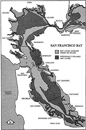
1960s map identifying potential landfill areas.
Image: U.S. Army Corps of Engineers
| The San Francisco Bay had been polluted without restraint for a century until the efforts to fill massive parts of the bay with land spurred 1960s activists and politicians to protect it. While these people have done much to protect the bay, the actions of various industries, including the shipping industry and the agriculture industry, continue to negatively affect it. Today’s bay is still plagued by toxic pollution though the rampant filling of the bay has been largely halted. |
In 1962, the city of Berkeley announced plans to double the physical size of the town by beginning to fill the 4,000 acres of Bay owned by Berkeley. Three university wives--Mrs. Clark Kerr, Mrs. Donald McLaughlin, and Mrs. Charles Gurlick--held a meeting in the Berkeley hills with local environmentalists where they founded the Save San Francisco Bay Association.
Political organizing in Berkeley derailed the landfill plans and even caused Santa Fe railroad to withdraw its plans to fill their shoreline holdings in the East Bay. But all around the San Francisco Bay in the mid-1960s plans were moving ahead to drastically alter the shoreline and make land--thousands of acres were slated to be filled. The San Francisco and Oakland airports were expanding, the city of Richmond planned to fill in thousands of tidal acres for further expansion of its industrial base, developers in Sausalito sought permission to extend the city several hundred yards into the Bay, eliminating the existing shoreline and obscuring the views with multiple-story apartments and offices. Perhaps the most dramatic threat to the Bay was along the Peninsula in San Mateo County. California highway engineers planned a second freeway paralleling today's Highway 101, and proposed to build it two miles out in the water of the Bay, skirting the eastern edge of the SF Airport. Once built, the area between the two freeways would become prime development acreage, needing only to be reclaimed from mud and tides. Where was the vast quantity of dirt to come from? San Bruno Mountain! Planners projected that 1 billion cubic yards of rock and soil could be chopped off the top of the mountain and deposited in the Bay, unleashing an unprecedented development/real estate boom, extending San Mateo County's size and creating billions in taxpaying property full of businesses and new residential neighborhoods.
Filling the Bay became a hot political issue all around San Francisco Bay. The Save San Francisco Bay Association, well-financed and politically connected, drew the attention of legislators representing the region in the California State Legislature. San Francisco's state senator Eugene McAteer worked with Assemblyman Nicholas Petris of the East Bay to usher a bill through the state legislature. In June 1965, the McAteer-Petris Act passed, establishing the San Francisco Bay Conservation and Development Commission in September 1965. Its purpose initially was to make "a detailed study of all the characteristics of the Bay, including the quality, quantity, and movement of Bay waters, . . . the ecological balance of the Bay, and the economic interests in the Bay, including the needs of the Bay Area population for industry and for employment. . . The study should examine all present and proposed uses of the Bay and its shoreline and . . . should lead to the preparation of a comprehensive and enforceable plan for the conservation of the water of the Bay and the development of its shoreline."
Various projects that were in the pipeline prior to the passage of the McAteer-Petris Act were grandfathered in and allowed to proceed. Bay Farm Island between Alameda and the Oakland Airport is a product of this political deal, without which it would still be a substantial wetland and haven for birds and bay wildlife. In general, however, and much to the chagrin of proponents of unrestrained growth, the Bay Conservation and Development Commission has stopped most efforts to fill the Bay, including the insane plans of San Mateo County and the city of Richmond. The state of the Bay today is much better thanks to the early environmental legislation that halted 120 years of piecemeal and unchecked filling of the Bay.
The Bay Today
Saving the Bay from ill-advised reclamation projects has been important, but the health of the Bay is still seriously compromised. Hydraulic gold mining in the 1860-1880 period washed billions of cubic yards of Sierra mountains down through the Central Valley and into the Bay. In that sediment are extraordinarily high levels of mercury, used widely in the 19th century to separate gold from its surrounding minerals. Other toxic heavy metals still persist in bay mud, resulting from decades of industrial pollution. Anti-pollution laws have reduced the flow of poison into the Bay, but it will be a hundred years before the existing toxics work their way out of the Bay.
An addition problem results from the Bay's function as the sewer for the agricultural runoff of the Central Valley. Selenium occurs naturally in Central Valley soils, but it gets concentrated in irrigation runoff, which is fed into the Bay's water at various locations in the Sacramento River delta. The selenium concentration is magnified when combined with the influx of exotic species that have rapidly occupied the Bay in the past decade.
Perhaps the most voracious invading species, and one that has done the most to alter the ecological balance of the Bay in recent years, is the Potamocorbula clam, better known as the Asian clam. They are rather tiny, only a half inch across the shell, but they are rapid reproducers. Apparently they have found their way into the Bay through the discharge of untreated ballast water from tankers calling on Bay ports. They were discovered in 1986 in the bottom of Suisun Bay in the northern part of SF Bay. In just one year they were the most common clam in the North Bay, and by 1991 they were the most common clam in all parts of the Bay. In some portions of the North Bay they have established beds that support between 20,000 to 30,000 claims per square meter, levels far above that reached by native species. According to Michael Lozeau of San Francisco BayKeeper, there are now so many in the North Bay that its estimated they circulate 1.5 times the volume of water (flowing through the North Bay) each day. They feed by sucking water through their siphons and extracting plankton and other sources of nutrition in the water. They have now wiped out blooms of phytoplankton, the tiny plants that are the foundation for all aquatic food webs. This denies food to native mollusks, crustaceans, and small fish, and ultimately will lead to a crash in species diversity in the San Francisco Bay, a process well underway.
Like many instances of exotic invasive species, they find a role in their new ecological niche. In the Bay, the Asian clams have become a favorite food source for white and green sturgeon, as well as diving ducks. But because they concentrate selenium in their tissue, selenium levels have risen by three times in these predator species, a worrisome development in light of the mid-1980s disaster at the Kesterson Wildlife Refuge in the Central Valley, where selenium-related deformities and defects caused a collapse in several bird species.
<iframe src="https://archive.org/embed/ssfBBPELICN" width="640" height="480" frameborder="0" webkitallowfullscreen="true" mozallowfullscreen="true" allowfullscreen></iframe>
1995 video from canoe, brown pelicans glide along SF waterfront.
Video: Chris Carlsson and Joel Pomerantz
Local environmental groups such as the San Francisco BayKeeper and the San Francisco Estuary Institute, among others, are closely monitoring the evolving health of the Bay. The Bays nature is undergoing rapid change, which isn't automatically a problem, but in light of what we know about the lethal mix of toxic waste and loss of genetic diversity, studies and remedial efforts are urgently underway.
Sources:
San Francisco Chronicle, Dec. 11, 1997 Threat to Bay Marine Life-Alien Critters Devouring Food Supply and March 17, 1999 Little Clams, Big Problems
Between the Devil and the Deep Blue Bay: The Struggle to San Francisco Bay by Harold Gilliam, San Francisco: Chronicle Books, 1969
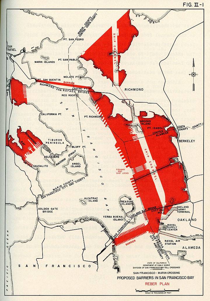
Map showing the Reber Plan, a post-World War II proposal.
Thanks to Eric Fischer for making this image, and many more, all in high resolution, available at his flickr account.
John Reber proposed in the post-WWII era that earthen dams be built across the bay in the north and south in order to create fresh water lakes. His idea was rejected in part because there were no mechanisms for regional planning at the time of his proposal, and the balkanized Bay Area communities could not come together on such a sweeping plan. Fresh water supplies were in any case secured from the rivers rushing out of the Sierra Nevada mountains, and the extreme ecological havoc that would have been caused by the Reber Plan never had a chance to get off the ground. The blackened areas on his map indicate areas of massive fill and industrial development. The ecological consequences of such a drastic alteration of the Bay's natural state are incalculable. Today we can only scratch our heads and be thankful that it never came to fruition.


