
File:Watershed map detail lake dolores.jpg
No higher resolution available.
Watershed_map_detail_lake_dolores.jpg (560 × 341 pixels, file size: 123 KB, MIME type: image/jpeg)
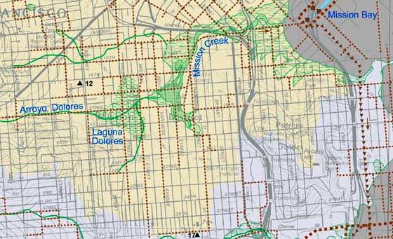
This is a portion of a watershed map published in 2007 created by Christopher Richard and his colleague Janet Sowers. It shows a Dolores Lagoon, but with no outline. Image from http://missionlocal.org/2011/02/unraveling-the-mystery-of-lake-dolores/
File history
Click on a date/time to view the file as it appeared at that time.
| Date/Time | Thumbnail | Dimensions | User | Comment | |
|---|---|---|---|---|---|
| current | 22:10, 25 February 2011 | | 560 × 341 (123 KB) | Lisaruth (talk | contribs) | This is a portion of a watershed map published in 2007 created by Christopher Richard and his colleague Janet Sowers. It shows a Dolores Lagoon, but with no outline. Image from http://missionlocal.org/2011/02/unraveling-the-mystery-of-lake-dolores/ |
You cannot overwrite this file.
File usage
The following page uses this file: