16th and Folsom: Difference between revisions
m (removed flood as a category, added water) |
No edit summary |
||
| (10 intermediate revisions by 2 users not shown) | |||
| Line 1: | Line 1: | ||
'''<font face = arial light> <font color = maroon> <font size = 3>Unfinished History</font></font> </font>''' | '''<font face = arial light> <font color = maroon> <font size = 3>Unfinished History</font></font> </font>''' | ||
[[Image:1905 16th | [[Image:1905 16th St, at Folsom, looking east. Streetcars driving through flood, car 770 wnp32.0263.jpg|800px]] | ||
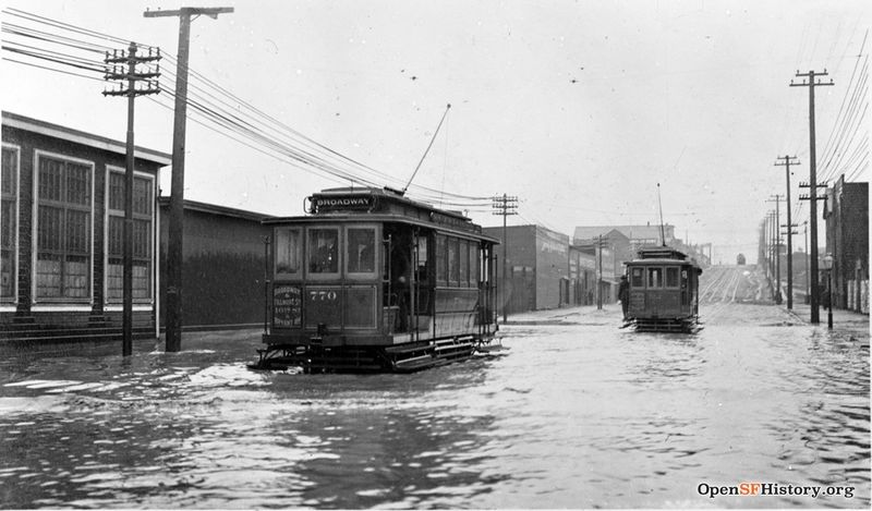
'''In 1905 streetcars struggle to pass through flooded intersection of 16th and Folsom. To the east the 16th Street hill goes up from Harrison to Bryant. Alongside this same block, from 1986-1995 resided the infamous underground music space, [[Komotion Gallery|Komotion International]].''' | '''In 1905 streetcars struggle to pass through flooded intersection of 16th and Folsom. To the east the 16th Street hill goes up from Harrison to Bryant. Alongside this same block, from 1986-1995 resided the infamous underground music space, [[Komotion Gallery|Komotion International]].''' | ||
''Photo: OpenSFHistory.org wnp32.0263'' | |||
[[category:Mission]] [[category:Transit]] [[category:1900s]] [[category:Water]] | [[Image:16th and Shotwell circa 1904 looking west to South Van Ness wnp32.0307.jpg|800px]] | ||
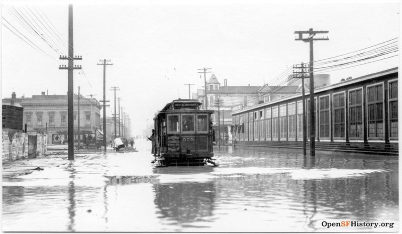
'''16th and Shotwell, c. 1904, looking west towards South Van Ness (then Howard).''' | |||
''Photo: OpenSFHistory.org wnp32.0307'' | |||
[[Image:16th & Alabama 1870 wnp71.2130.jpg|800px]] | |||
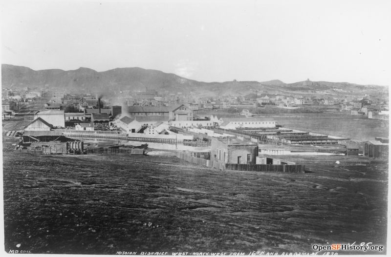
'''View west from apx. 16th and Alabama, c. 1870.''' | |||
''Photo: OpenSFHistory.org wnp71.2130'' | |||
[[Image:16th near Mission circa 1869 Pacific Chemical Works view south towards Bernal wnp36.03624.jpg]] | |||
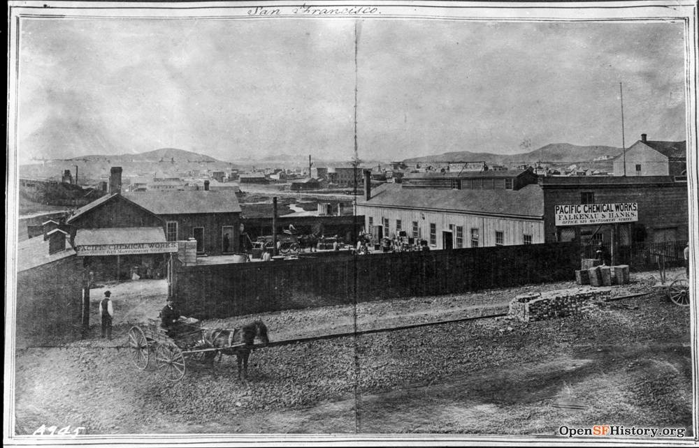
'''Pacific Chemical Works at 16th near Mission Creek in 1869, was probably very near the same location as the photo below.''' | |||
''Photo: OpenSFHistory.org wnp36.03624'' | |||
[[Image:16th-and-Folsom-Kilpatricks-store-after-closing-2014 P1080652.jpg]] | |||
'''16th and Folsom, Kilpatricks bread store, after closing, 2014.''' | |||
''Photo: Chris Carlsson'' | |||
[[Image:16th-and-Folsom-2014 P1080648.jpg]] | |||
'''Same corner, longer view, 2014.''' | |||
''Photo: Chris Carlsson'' | |||
[[Image:US-Steel-at-16th-and-Folsom.jpg]] | |||
'''[[Industrial San Francisco in the 1970s|U.S. Steel warehouse]] at 16th and Folsom, 1960s, later converted to a MUNI barn.''' | |||
''Photo: Francisco FloresLanda'' | |||
[[Image:M2382 4 16th-and-Harrison-US-Steel-June-9-1977.jpg|800px]] | |||
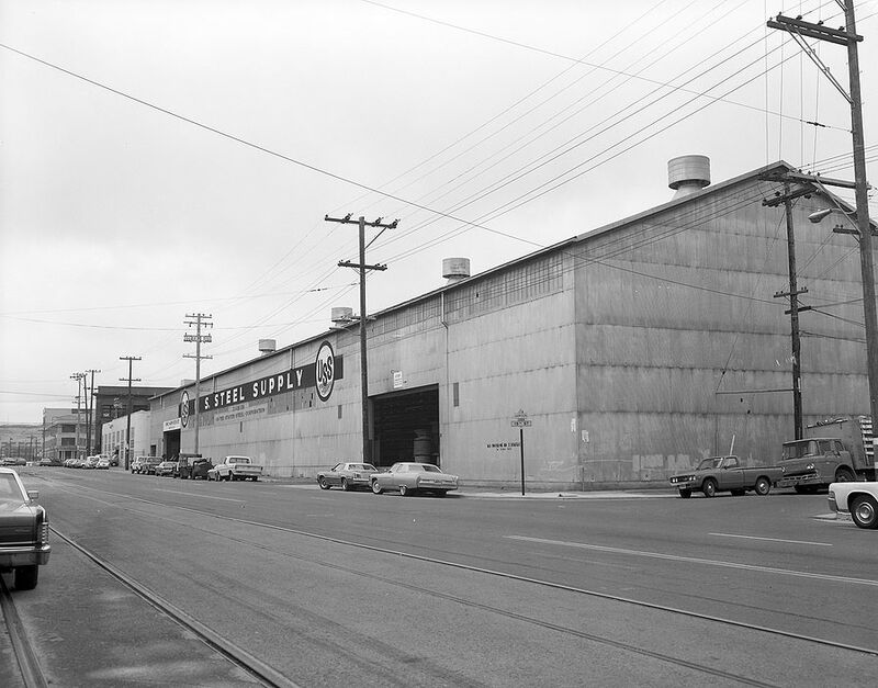
'''16th and Folsom, southwest corner of US Steel warehouse, June 9, 1977.''' | |||
''Photo: courtesy SFMTA photo collection, M2382 4'' | |||
[[Image:M2382 13 interior-of-US-Steel-June-9-1977.jpg|800px]] | |||
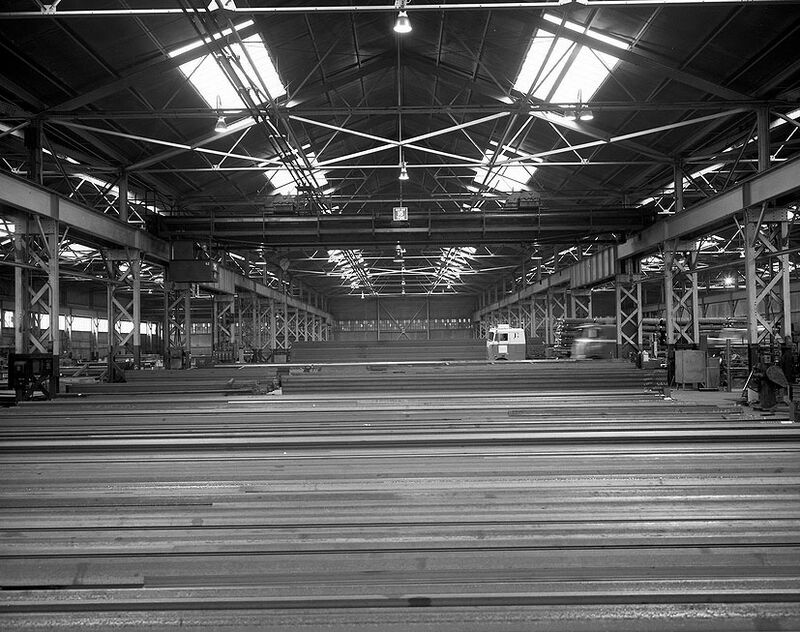
'''Interior of US Steel warehouse, June 9, 1977.''' | |||
''Photo: courtesy SFMTA photo collection, M2382 13'' | |||
[[Image:M2382 5 US-Steel-June-1977-Harrison-and-15th-looking-south.jpg|800px]] | |||
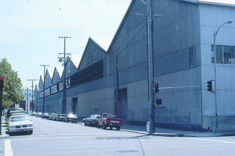
'''Opposite (northeast) corner of US Steel warehouse, Harrison and 15th, looking south, June 1977.''' | |||
''Photo: courtesy SFMTA photo collection, M2382 5'' | |||
[[Image:East at the south side of 15th Street from Folsom Street to Treat Avenue - 1987 Kirkeberg Diva 1512877.750x.png]] | |||
'''East at the south side of 15th Street from Folsom Street to Treat Avenue - 1987.''' | |||
''Photo: Max Kirkeberg Collection, Diva.sfsu.edu'' | |||
[[18th St Gulch, The Willows, Valencia St Hotel|Prev. Document]] [[Tanforan Cottages from 1853|Next Document]] | |||
[[category:Mission]] [[category:Transit]] [[category:1900s]] [[category:1960s]] [[category:1970s]] [[category:1980s]] [[category:Water]] [[category:1860s]] [[category:Corporations]] [[category:buildings]] | |||
Latest revision as of 14:20, 20 October 2022
Unfinished History
In 1905 streetcars struggle to pass through flooded intersection of 16th and Folsom. To the east the 16th Street hill goes up from Harrison to Bryant. Alongside this same block, from 1986-1995 resided the infamous underground music space, Komotion International.
Photo: OpenSFHistory.org wnp32.0263
16th and Shotwell, c. 1904, looking west towards South Van Ness (then Howard).
Photo: OpenSFHistory.org wnp32.0307
View west from apx. 16th and Alabama, c. 1870.
Photo: OpenSFHistory.org wnp71.2130
Pacific Chemical Works at 16th near Mission Creek in 1869, was probably very near the same location as the photo below.
Photo: OpenSFHistory.org wnp36.03624
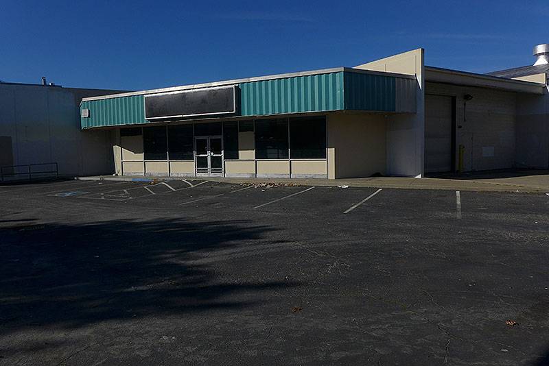
16th and Folsom, Kilpatricks bread store, after closing, 2014.
Photo: Chris Carlsson
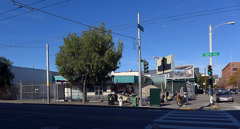
Same corner, longer view, 2014.
Photo: Chris Carlsson
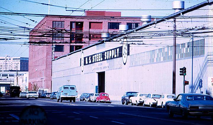
U.S. Steel warehouse at 16th and Folsom, 1960s, later converted to a MUNI barn.
Photo: Francisco FloresLanda
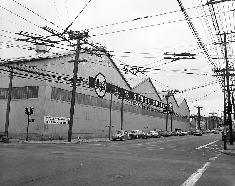
16th and Folsom, southwest corner of US Steel warehouse, June 9, 1977.
Photo: courtesy SFMTA photo collection, M2382 4
Interior of US Steel warehouse, June 9, 1977.
Photo: courtesy SFMTA photo collection, M2382 13
Opposite (northeast) corner of US Steel warehouse, Harrison and 15th, looking south, June 1977.
Photo: courtesy SFMTA photo collection, M2382 5
East at the south side of 15th Street from Folsom Street to Treat Avenue - 1987.
Photo: Max Kirkeberg Collection, Diva.sfsu.edu

